Capital Cities and Capitol Buildings: Seats of State Government Across America (Part 1)
LISTEN ON SOUNDCLOUD:
American state capital cities are an organic part of the American landscape. Capital cities sprung up along the natural waterways and pathways of American travel and commerce. Some grew next to the mighty rivers and others at the junction of major trade routes. Some are in the foothills while others are on the plains, some on the coastal bays and others far inland. Some emerged from the bareness of the great plains while others emerged from the small neighborhoods, burgs and towns that dotted the landscape. Some are located in major urban centers while others snuggle into smaller, rural communities. The fifty American state capital cities provide a unique study in the diversity and richness of the American experience.
The oldest American capital cities grew on opposite sides of the continent. Santa Fe was founded in 1610 as the first colonial American capital city followed by Boston in 1630. Santa Fe was designated as capital of the new Spanish colony of Santa Fe de Nuevo México and was situated in the foothills of the Sangre de Cristo mountains. Thirty years later the British Massachusetts Bay Colony established its capital on what was then known as Trimountaine, or Three Mountains, later to be renamed Boston after Lincolnshire, England previous home of some of the prominent colonists.
The newest state capital cities are also the largest in size. The Alaskan capital of Juneau dates back to 1881 and covers a total area of over 4,800 square miles, almost half of which is water. Oklahoma City grew out of the land rush of 1889 and now covers just over 600 square miles. Phoenix is a not too far distant third in size covering 516 square miles, but Phoenix ranks first in population with over 2 million people. The smallest state capital cities tend to be older and back east. The smallest state capital in population is Montpelier with around 8,000 people and the smallest capital city by geographic size is Hartford with just over 17 square miles.
Some capital cities grew at the junction of major trade routes. Nashville was planted as a port on the shores of the Cumberland River, a major tributary of the Ohio River, and it later became a railway hub linking together southern and northern commerce. Kansas City was founded as a port on the Missouri River at the confluence with the Kansas River and then grew into a major launching point for westward expansion as the trailhead of the Santa Fe, Oregon and California Trails.
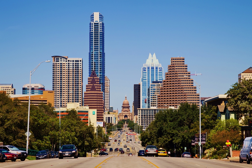
Many state capitals have moved from several cities before arriving at their present location. Chillicothe was the first capital city of Ohio before it was moved Zanesville in an attempt to establish more development in the eastern part of the state along Zane’s Trace. But political powers pulled the capital back to Chillicothe for two years before finally landing in Columbus. The capital of Texas has moved several times. During the Texas War for Independence, the revolutionary government established capitals at Washington-on-the-Brazos, Harrisburg, Galveston, Velasco, and Columbia before General Sam Houston finally moved it to Houston. As an independent nation, President Mirabeau B. Lamar envisioned a Texas growing west and moved the capital to a more central location in the small town of Waterloo, later to become Austin. Houston was elected President and feared the new location was too remote and too difficult to defend from Mexican and native American threats, so he moved the capital first back to Houston and then to Washington-on-the-Brazos. In an incident known as the Texas Archive War, President Houston sent troops to seize the General Land Office records in Austin and take them to the city of Houston. A band of Austin citizens engaged the troops on the outskirts of town, preventing the records from being removed and taken to Houston and Austin was thereby firmly established as the capital of Texas.
While many state capital cities grew up organically from the geology and geography of the land, some were planned from the beginning. Upon his arrival in the Salt Lake Valley, pioneer and president of the Mormon Church, Brigham Young, envisioned a master-planned city built around a new Salt Lake Temple. Every inch of the city was measured from Temple Square as the meridian of reference for street addresses forming a grid of the streets that were sufficiently wide enough so a wagon team could turn around without “resorting to profanity.” The capital of Indiana was also a planned community, springing out from Monument Circle in a grid crisscrossed by diagonals reminiscent of the national capital.
Finally, it is important to note that many state capital cities predate the ratification of the national constitution and the subsequent construction of the national capital of Washington, D.C. While Frenchman Pierre Charles L’Enfant looked to the great cities of the world for his design, especially his hometown of Paris, his design for the tidelands and the marshy swamps of the Potomac worked in the basic constitutional commitments to a federal form of government. His design provided the national government with a shape and design while incorporating specific centers, streets and areas devoted to the particular states. So, even the shape and design of the District of Columbia anticipates a truly federal form of government for the United States, one in which the balance of power resides in both spheres of American government, state and national. The designations of special spaces in the District of Columbia and even the street names and places anticipate a truly diverse political state, one where the balance of power between state and nation is shared, in stark contrast to the modern notion of centralized governmental control emanating only from within the Beltway.
Regardless of size, shape, design or location, state capital cities bear one common trait: they form the context in which their individual state capitol buildings sit. At times small and cloistered, at times big and wide open, the community of the capital city forms the foundation on which each state capitol is built.
Greg Davidson is the Executive Clerk to the Governor and director of the Constituent Communication Division of the Office of the Governor in Texas. Over the past 30 years, Greg has worked for Texas Governors Clements, Bush, Perry, and Abbott. Greg holds a Master of Arts in government and a BBA in Marketing from the University of Texas at Austin. He also holds a Master of Divinity degree from the Austin Presbyterian Theological Seminary and currently serves as the Stated Clerk for the South Texas Presbytery of the Presbyterian Church in America. Greg was elected to serve as a presidential elector in the United States Electoral College and has been involved in presidential, gubernatorial, congressional, state, and local campaigns since 1976. He resides in Austin, Texas with his wife Donna Garcia Davidson who is an attorney in private practice concentrating in the area of campaign finance and election law. They have one daughter, a senior at Regents School of Austin, who intends to go to college, study engineering or law, and play competitive golf.
Click Here to have the NEWEST essay in this study emailed to your inbox every day!
Click Here to view the schedule of topics in our 90 Day Study on Congress.


Phoenix has about 1.7 million people, not over 2 million, as stated. Hartford is not the smallest in size, that goes to Trenton, New Jersey, which only covers 8 square miles, less than half of Hartford’s area.